Pork & Fork Festival address
Pork & Fork Fest
Joel C. Bradshaw Fairgrounds
21311 Courthouse Highway
Windsor, VA 23487
The Fairgrounds at Heritage Park are located on Rt. 258 about 2 miles from Highway 460 in Windsor and about 12 miles from Smithfield.
Joel C. Bradshaw Fairgrounds
21311 Courthouse Highway
Windsor, VA 23487
The Fairgrounds at Heritage Park are located on Rt. 258 about 2 miles from Highway 460 in Windsor and about 12 miles from Smithfield.
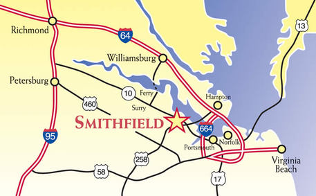
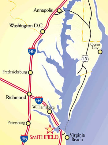
It’s easy to get to Smithfield & Isle of Wight County...
Smithfield is the number one day-trip destination from Williamsburg and the Historic Triangle, and it’s easy to get here, whether you’re traveling by car or boat. While you’re on the way, you’ll enjoy beautiful drives by fields and fantastic water views along the shores that helped found our nation.
For GPS Directions, the address of our Visitor Center is 319 Main St. Smithfield, Virginia.
For GPS Directions, the address of our Visitor Center is 319 Main St. Smithfield, Virginia.
Driving directions...
From the North and South via Interstate 95 and/or via 64 East/West:
From the North, follow Interstate 95 South to Richmond area;
From the South, Follow Interstate 95 North;
Or if traveling I-85, join 95 south of Richmond;
From the North, follow Interstate 95 South to Richmond area;
From the South, Follow Interstate 95 North;
Or if traveling I-85, join 95 south of Richmond;
- Around Richmond, follow signs that state I-295 South/ I-64 East to Norfolk/Williamsburg.
- Continue on I-64 East past Williamsburg, or I-64 West if approaching from Norfolk/Virginia Beach area, to the Hampton exit Mercury Blvd/James River Bridge;
- Follow Mercury Blvd until it becomes James River Bridge/Route 17 and cross over the Bridge into Isle of Wight County;
- At turn right onto Route 10/32 Smithfield;
- At first light, turn right onto Route 10 West;
- Turn right onto Route 258 (Main Street) and follow shortly into the Historic District of Smithfield
- If coming from the Southwest via Interstate 40 in North Carolina, I-40 will intersect with Interstates 95 and 85 - please refer to those directions;
- From the West and North via Interstate 81, I-81 meets Interstate 64 in Staunton, Virginia; please refer to the directions pertaining to I-64 going East;
- Take I-77 into Virginia where it meets with I-81 Around the Wytheville area; from there you can follow I-81 to Staunton, where I-81 meets I-64; from I-64, please refer to the directions pertaining to I-64 going East;
- You can follow I-81 North to Blacksburg and pick up Route 460 East, which is for the majority a 4 lane divided highway; Follow Route 460 East for approximately 40 miles to the intersection of Route 258 at Windsor; Turn left onto Route 258 and follow for approximately 15 miles where 258 becomes Main Street in the Historic District of Smithfield
By boat...
Smithfield, Virginia is located on the Pagan River which feeds directly into the James River. The directions listed below will get you and your water vessel to Smithfield Station Waterfront Inn and Marina.
The Pagan was recently dredged by the Army Corp of Engineers and the channel is now maintained to a minimum depth of 10 feet, creating ample depth for vessels with 6-foot drafts to get up to Smithfield Station.
The Pagan was recently dredged by the Army Corp of Engineers and the channel is now maintained to a minimum depth of 10 feet, creating ample depth for vessels with 6-foot drafts to get up to Smithfield Station.
- Proceed through the high rise draw at the James River Bridge;
- Head for Days Point - the point of land on the far side of the mouth of the Pagan River. The Pagan River will be the first river opening on the left after the James River Bridge;
- Look for the Red "2 Day" marker at the mouth of the Pagan River. Follow the day markers to the Pagan River to Smithfield Station.
- As you continue on the Pagan River, follow the day markers closely. There are several shallow points off the channel.